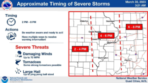
OTTAWA – North Central Illinois could face some severe thunderstorms this afternoon through mid-evening. Damaging winds, large hail, and the potential for tornadoes are all possible this afternoon, according to the National Weather Service. There is also a wind advisory in effect from 3 PM today until 1 PM Saturday, with sustained winds between 25 and 35 mph as well as gusts that could exceed 50 mph. Officials say everyone should be prepared and have multiple ways to receive breaking weather reports.
According to National Weather Service Meteorologist Matt Friedline, the likelihood will be between 2 PM and 10 PM, developing in Eastern Iowa toward the Mississippi River and working their way eastward. There may be a couple of storms during that time, and we could see the humidity in the evening. This will set the stage for some strong thunderstorms and possibly tornadoes.